By James Spann
Alabama Newscenter
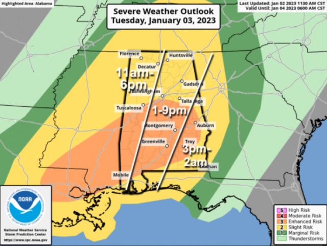
A dynamic weather system will bring the chance of strong to severe thunderstorms to Alabama Tuesday afternoon and evening. The Storm Prediction Center maintains an enhanced risk (level 3 of 5) for much of central and southwest Alabama, for areas south of a line from Tuscaloosa to Birmingham to Opelika. A slight risk (level 2) covers the rest of the state.
While rain is possible during the morning, the window for strong to severe thunderstorms will open around 11 a.m. over the western third of the state, with the risk shifting eastward through the afternoon and evening. Thunderstorms that form will be capable of producing strong winds, hail and a few tornadoes. A strong tornado (EF-2 or higher) is possible in the enhanced risk area.
Rain amounts of around 1 inch are likely, with isolated heavier amounts possible. The severe weather threat will fade Tuesday night as the main dynamic support lifts well to the north of Alabama, but rain will remain possible through Wednesday morning.
PREPARE: Be sure you can hear severe weather warnings if they are needed. A NOAA Weather Radio is the baseline, and be sure Wireless Emergency Alerts are enabled on your phone. Install the free ABC 33/40 weather app.
Review your severe weather plan; know the safe place in your home, which is a small room on the lowest floor, near the center of the house, away from windows. If you live in a mobile home, be sure you know the location of the nearest shelter or site-built structure that is available, and the quickest way of getting there.
No need to be anxious; these setups are common in Alabama during our tornado season, which runs from November through May.
REST OF THE WEEK: Rain will end Wednesday morning, and the weather will be dry and cooler Thursday and Friday with seasonal temperatures (highs in the 50s, lows in the 30s).


